
|
In the Wabakimi Area, there are many other wilderness canoeing opportunities both in protected areas and on Crown lands. Together with Wabakimi Provincial Park, these functionally-roadless lands constitute the world's largest contiguous wilderness canoeing area.
|
|
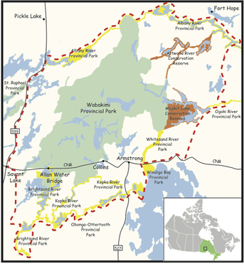
provincial parksWabakimi Provincial Park is bounded on the north by Albany River Provincial Park and on the south by Kopka River, Obonga-Ottertooth, Gull River and Brightsand River Provincial Parks. To the west lies St. Raphael Provincial Park and to the east, Whitesand, Windigo Bay and Ogoki River Provincial Parks.
|
|
Ontario boasts a proud heritage of provincial park development that began over a century ago. In 1999, Ontario's Living Legacy (OLL) announced a land use strategy that identified 278 new protected areas including 61 new parks and 45 park additions--a protected area of over 2.4 million hectares (ha) of land, including 900,000ha of additions to the provincial parks system. Ontario now has a total of 100+ operating parks and 220+ non-operating parks encompassing 8.2 million hectares or 7.6% of the province's area. Over 9 million visitors enjoy Ontario parks annually.
In the immediate area beyond Wabakimi Provincial Park, there are more than 300,000ha of other provincial parks, many of which were created or expanded as part of OLL. The chart below lists those closest to Wabakimi in order of size. Descriptions of the commercial and recreational land uses and activities currently permitted in each of these parks are available in their respective policy reports posted in the Crown Land Use Policy Atlas (CLUPA). Read and/or download the PDF file for complete information.
|
|
|
Conservation reserves are a relatively new type of protected area. Originally established in 1994 under the Public Lands Act to protect natural heritage features and provide recreation opportunities on public lands, these areas have fewer restrictions on recreational and commercial uses than provincial parks. However, commercial logging, mining, hydro-electric power development and other industrial uses are prohibited.
Read and/or download the PDF file for complete information.
|
|
|
Most Crown land in Ontario is administered by the Ministry of Natural Resources & Forestry (MNRF), however, national parks, Indian reserves and some harbours, airports and canal systems are controlled by the Canadian federal government. Provincial parks and conservation reserves are Crown lands that are planned, developed and managed by Ontario Parks.
In total, Crown land makes up about 87% of Ontario's land mass, or 937,000 square kilometres. Land on the beds of most navigable lakes and rivers is considered provincial Crown land. These beds alone constitute over 164,000 square kilometres, mostly under the Great Lakes system. With the exception of the "land under water", there is very little Crown land in Southern Ontario. In Northern Ontario, provincial Crown land makes up over 95% of the land base. Read and/or download the PDF file for complete information.
|
|
The Environmental Registry (commonly called the "Registry") is an on-line database used by Ontario ministries and agencies to post public notices of any government proposal or decision that may impact the province's environment. These notices may contain information about proposed new laws, regulations, policies and programs or about proposals to change or eliminate existing ones. Provision is made for public comment and for notification of future announcements related to any environmental matter of interest.
The Registry is an important part of ensuring that the public can participate in decisions being made about environmental issues. It is the only one of its kind in Canada and was created in 1993 under Ontario's Environmental Bill of Rights (EBR). The Environmental Commissioner of Ontario is responsible for monitoring that the government ministries and agencies fulfill their obligations under the EBR including the Registry.
The Registry is an important part of ensuring that the public can participate in decisions being made about environmental issues. It is the only one of its kind in Canada and was created in 1993 under Ontario's Environmental Bill of Rights (EBR). The Environmental Commissioner of Ontario is responsible for monitoring that the government ministries and agencies fulfill their obligations under the EBR including the Registry.