
|
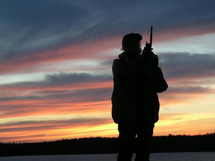
Phil Cotton - An avid canoe historian and retired music teacher, “Uncle” Phil managed The Wabakimi Project which he founded in 2004 until his passing in May 2018. His winters were spent researching and planning routes, recruiting volunteers, organizing the annual speaking tour and preparing equipment and supplies for the next summer's reconnaissance expeditions. Phil’s home in Thunder Bay, Ontario provided a welcoming base of operations.
|
|
In this age of government cutbacks of human and financial resources, it falls to those who treasure our shrinking wilderness to become proactive in the protection and preservation of canoe routes and their associated values. These values include public access points, portage trails, backcountry campsites and viewscapes as well as sites of historical, cultural and natural interest.
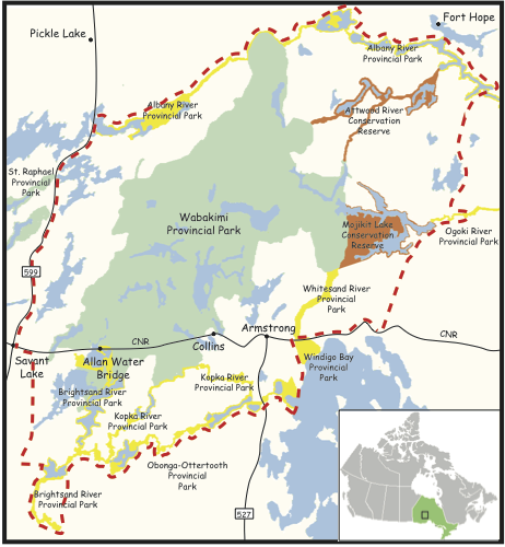
Volunteers who participated in The Wabakimi Project helped make the Wabakimi Area more inviting and user-friendly by exploring and documenting its historical and traditional canoe routes particularly those that have been neglected and fallen into disrepair. Preservation of these canoe route values will make backcountry travel safer, disperse visitor traffic over a wider area, reduce the frequency of human encounters, lessen the impact of human activity on the environment and enhance users' nature-based wilderness activities for generations to come. Beyond Wabakimi, the canoe routes that lie on the adjacent Crown lands are an integral component of the park's values but they do not enjoy the same degree of protection as those within the park. They are prone to the impacts of road development and resource-extraction activities. The Wabakimi Project confirmed the existence and condition of these canoe routes and shared this information with the Ontario Ministry of Natural Resources & Forestry (MNRF) and other stakeholders to negotiate their recognition and improved protection. The primary purpose of The Wabakimi Project was to produce detailed maps to help visitors plan and mount canoe trips in the Wabakimi Area. This lofty ambition has been realized with the publication of five volumes of Wabakimi Canoe Route Maps. Now completed, the copyright and the sale of these maps is now part of the Friends of Wabakimi. Proceeds from the sale of these map booklets are used to further the work of Friends of Wabakimi. |
|
|
2018
Over 55 days, 31 volunteers explored and worked on the Raymond River routes. The first crew flew into Scallop Lake and worked on the portages east, but not quite to the intersection with the North-South route coming out of Annette Lake. They then turned west and upstream through several lakes on the Raymond River route and the south to Medallion, Hollingsworth and Howie lakes to connect with Caribou Lake. The Raymond River route is the new addition to Volume 5. The Mattice Lake to Pillar Lake route was cleared, leaving the last connection into Nameiben Lake for a future project. A special thanks to Debbie Doyle-Sargent for keeping The Wabakimi Project organized after Phil Cotton’s sudden passing. 2017 Over 40 days, 21 volunteers explored and cleared Rushbay Lake going east through ponds to Vale creek. Then Rushbay Lake down the Collins River to Hwy 527 route was completed. Additional work on the Vale Creek routes going north from the Mountain Lake portage toward Alter Lake completed the Vale Creek route. 2016 Over 72 days, 27 volunteers of The Wabakimi Project explored canoe routes in the Wabakimi Area that traverse the Atlantic/Arctic Height of Land into the Lake Nipigon watershed via the Big River and into the Kopka River via Vale Creek. Together, they travelled back and forth over 48km (30 miles) of new and existing canoe routes, located and inventoried 28 new campsites and cleared and mapped 33 new portages that measured a total of 4,580m (5,009 yards or 911 rods). In 4 weeks during late May/June, the route from Tamarack Lake to Waweig Lake via Rocky Island, Tunnel, Mountain, Vale and Nameiben Lakes was completed. In 6 weeks from late July to mid-September, work begun in 2015 in the Big River watershed continued. The remainder of the route via Big River upstream from Moonshine Lake to D’Alton Lake and the route connecting D’Alton Lake to Caribou Lake via Fuchsite and Michell Lakes were established. Routes explored by reconnaissance expeditions of The Wabakimi Project are depicted on the 2016 Route Map as dashed, black lines. Special thanks are due to the growing number of ‘contributors’ who submitted trip reports of their self-directed, self-guided trips in the Wabakimi Area. Their contributions help organizers of The Wabakimi Project to monitor the condition of canoe routes already established by volunteer reconnaissance expeditions and to promote visitation to the Wabakimi Area by future generations of wilderness paddlers. The routes they followed are shown on the 2016 Route Map as dashed, red lines. 2015 Over a period of 9 weeks, 25 participants explored the 5 canoe routes that lead over the Atlantic/Arctic Height of Land from Little Caribou Lake and Caribou Lake into the Lake Nipigon watershed. Inclement weather and the condition of portages encountered severely restricted what was ultimately accomplished in the time available. Nonetheless, 81km (50 miles) of canoe routes were explored, 27 campsites were identified and inventoried and 32 portages were located and cleared that measured a total of 9,840m (10,761 yards or 2,140 rods). In late May and early June, the routes from Caribou Lake to Cumaway Lake and Linklater Lake were cleared, measured and mapped. The other three routes were either not located or left incomplete and will be attempted in future trips. From late July, through August and into early September, the routes from Linklater Lake via Linklater Creek to Amra Lake and Upper Pawshowconk Lake and upstream from Upper Pawshowconk Lake via the Big River to Shoal, Reef and Moonshine Lakes were completed as was the link between Moonshine Lake and Amra Lake via Ruxton and Cosmo Lakes. 2014 In 10 weeks, 12 past participants and 11 new participants attempted once more to complete the routes for Volume Four of the Wabakimi Canoe Routes Maps series of map booklets. Over 72 days, 208km (130 miles) of canoe routes were explored, 53 campsites were located and inventoried and 34 portages were located and cleared that measured a total of 14,822m (16.209 yards or 2,947 rods). In the first 6 weeks, the route from Kellar Lake on the Opichuan River upstream via the Cat Tail River through Elbow, Muskrat and Gordon Reid Lakes to Kagianagami Lake was opened and mapped. The final portage on the Opichuan River was cleared and measured before proceeding to Mahamo Lake and on through French Lake to the Ogoki River. The final trip prior to the July hiatus was unable to reach the Ogoki Reservoir due to extremely high water conditions on the Ogoki River and was forced to return to Mahamo Lake for the extraction flight. In the first two weeks of August, the Little Jackfish River route from Mojikit Lake to the Airport/Jackfish Road leading to Armstrong was explored and mapped. During the final two trips, the route from Upper Pawshowconk Lake down the Big River to Gort Lake and then down the Pikitigushi River through Wash, Derraugh and Pikitigushi Lakes to the same road was completed. These two routes offer visitors to the Wabakimi Area an economical means of extraction from canoe routes as far away as the Albany River. 2013 In 11 weeks (79 days), 6 new participants and 17 past participants attempted to complete the routes to be included in Volume Four of the Wabakimi Canoe Routes Maps series of map booklets. In the first 4 weeks, the route from Patte Lake on the Albany River to Attwood Lake via Shabuskwia, Musgrave, Kilbarry and Luella Lakes was re-established. From there, the route down the Attwood River to Guerin Lake was re-visited and the canoes left there for the July hiatus. In the next 4 weeks, the route from Guerin Lake to Gordon Reid Lake via Yolanda, Peninsular, Horsehoe, Studd, Elbow and Muskrat Lakes was re-opened. Completion of the route to Humble Bay of Kagianagami Lake in the remaining 2 weeks was not feasible so, the route through Muskrat Lake to Elbow Lake was re-traced and the Cat Tail River descended into Kellow Lake on the Opichuan River system. From there, the penultimate portage to Kagianagami Lake was opened. Despite the limited operating season, 254km (158 miles) of canoe routes were covered, 52 campsites located and 41 portages cleared that measured 14,498m (15,855 yards or 2,283 rods). Completion of the two routes to Kagianagami Lake in 2014 will re-establish the historically-significant links between the Albany and Ogoki Rivers. 2012 In a shortened season of 13 weeks totaling 93 days, 11 new participants joined 25 past participants on 12 trips to work on the canoe routes that link the Albany and Ogoki Rivers to Lake Nipigon east of Wabakimi Provincial Park. Reconnaissance of the route from Whiteclay Lake on the Ogoki River to Gowie Bay on the Albany River via the Witchwood and Attwood Rivers was completed and all but 2,400m of the Opichuan River route between Abizotikichuan Lake and Kagianagami Lake were completed too. Low water levels and the condition of portages and campsites again limited the overall distance covered. In all, 119km (74 miles) of canoe routes were documented, 40 campsites located and cleaned and 30 portages cleared that measured 10,006m (10,943 yards or 1990 rods). 2011 In 13 weeks (94 days), 12 trips involving 31 participants completed reconnaissance of the Misehkow River and the Albany River from Achapi Lake to Frenchmans Rapids below Fort Hope. Two canoe routes that lie on Crown land near Armstrong, ON were also explored and documented. Extremely low water levels, an intense forest fire season, the condition of unmaintained portages and the volumes of trash on campsites and along shorelines that needed to be collected severely limited the overall distance covered. As a result, publication of Volume Four of the Wabakimi Canoe Routes booklets will be delayed until reconnaissance of the southern tributaries of the Albany River is completed in 2012. 2010 Over a total of 114 days, 14 trips involving 38 participants covered 512km of canoe routes across the southern part of the park from Smye Lake west of Heathcote Lake to Maggotte Lake south of the Kopka River. Not all of the routes planned were completed due to weather and the condition of many of the portages encountered. Several sheer wind occurences dictated the need to revisit some routes completed earlier in the season to ensure they were again safe to use. Beside the overall distance covered, several other records were set this year: 160 campsites were inventoried and cleaned; 153 portages whose lengths totaled 39,990m were cleared and measured. 2009 Over 104 days, 13 trips involving 35 different participants covered 397km on the Caribou Forest from the CN railway line north to the Albany River. Unusually wet and bitterly cold weather coupled with extremely high water levels and the deplorable condition of many of the portages encountered conspired to limit the work completed and the total distance travelled. Reconnaissance of the Albany River was abandoned at Achapi Lake as it was too dangerous to proceed any further downstream. Despite these setbacks, reconnaissance of most of the canoe routes south of Savant Lake was completed, 96 campsites were identified and cleaned, and 74 portages whose lengths totaled 17,123m were located, rehabilitated and measured. The number of routes visited and the overall area covered was substantially augmented by contributors who mounted their own self-directed trips and afterwards submitted detailed trip reports. Their routes are depicted in red while the routes followed by the reconnaissance expeditions are shown as a single, continuous black line. 2008 Fifteen trips involving 44 participants ran continuously for 17 weeks (121 days) and, for the first time, involved leaders other than "Uncle" Phil. Barry Simon led an 8-day trip in early July to give Phil a break and Doug Blount led a 2-week trip in mid-August while Phil attended his daughter's wedding in Thunder Bay. Most of the canoe routes in the Caribou Forest from Savant Lake to Pashkokogan Lake were completed including the Little Pashkokogan River that runs through St. Raphael Provincial Park on the west side of Highway 599. Doug's trip crossed the entire width of the park all the way to the Ogoki Reservoir. 2007 The same schedule as in 2006 (see below) was continued but with no 2-week trips, 33 different participants were involved two of whom returned for a second trip. The first 6-week series of trips were spent exploring the Crown land canoe routes between the western boundary of Wabakimi Provincial Park and Highway 599 in an area known as the Caribou Forest. The second 6-week series involved crossing the entire width of the park from Rockcliff Lake to the Pikitigushi River. 2006 Trips were standardized into two six-week blocks with a 4-week hiatus in July for Phil to rest and re-pack. Nine 8-day trips and one 15-day trip involved 30 different participants over a total of 87 days. The summer's routes included reconnaissance of the entire length of the Flindt River from the railhead to Wabakimi Lake as well as initial exploration of the western approach to the park from Greenbush Lake via the Misehkow River. 2005 The initial trips in 2004 convinced Phil that, without better organization, more people and a more ambitious schedule, reconnaissance of all the lost/abandoned routes of Wabakimi would never be completed. Two 'series' of trips each involving 3-person 'teams' of volunteers led by Phil were designed. Seven trips varying in duration from eight to fifteen days were blocked into two 'series' involved 21 participants over a total of 76 days. The focus of these trips was to complete work begun in 2004 and extend the scope of reconnaissance to other northern tributaries of the Ogoki River. The Ogoki-Albany Height of Land was crossed twice--once from Colehouse Lake into Rockcliff Lake and again from Davies Lake into Muskiga Lake. 2004 The Wabakimi Project had its genesis in an early Spring fly-in/fly-out trip when Phil and his friend, Wes McCoy, undertook an exploration of Corky Creek. In 22 days, starting from Winn Lake, they paddled the entire extent of this abandoned waterway and discovered no less than four links to other routes. In August, Phil and his son, John, conducted a 10-day reconnaissance of Webster Creek to establish three of the four links to Corky Creek. |