
|
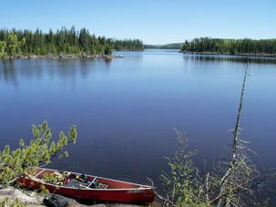
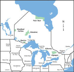
Wabakimi Provincial Park is located in Canada's Northwestern Ontario some 240km (150 miles) north of Thunder Bay. It is one of the three most popular regional canoeing destinations, the others being Quetico Provincial Park and Woodland Caribou Provincial Park.
|
|
|
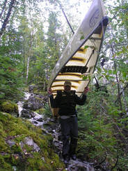
By far, the best way to reach the more remote, less-travelled parts of the Wabakimi Area is by air. Several area outfitters offer charter float plane service as well as overnight accommodation, vehicle parking and road shuttles. Most issue fishing licences and camping permits; some rent canoes. A few offer full and partial outfitting as well as trip planning and route orientation. |
by roadDownload the PDF file for complete information. |
Wabakimi Provincial Park was created and regulated in 1983. In 1997, it was expanded six-fold and as such, contributed to achievement of the government's ambitious goal to set aside 12% of the province's land mass as protected areas.
Download the PDF file for complete information.
Download the PDF file for complete information.
|
Wabakimi is Ontario's second largest provincial park, larger than Algonquin or Quetico and Woodland Caribou combined but with far fewer visitors and no entry quota or campsite assignment systems. The original 'core' area of Wabakimi Provincial Park that was regulated in 1983 comprised about 155,000 hectares. In 1997, the park was expanded by about 737,000 hectares creating a total area of 892,061 hectares. For a comparison of the area of Wabakimi Provincial Park to that of other popular canoeing provincial parks, download the PDF file. |
Wabakimi Provincial Park lies entirely within the boreal forest – a broad-belted ecosystem that encircles the globe in the northern hemisphere. The boreal forest is the world’s largest terrestrial ecosystem, larger than the Amazon rainforest. Tree species include black spruce and jack pine with some trembling aspen and white birch in upland areas and larch (or tamarack) in the wet, organic lowlands found in bedrock depressions. Cedar and balsam fir are common too, however, the predominant flora are shrubs, mosses and lichens, the latter being the primary food source of the woodland caribou. Large mammals native to the park include woodland caribou, moose, white tailed deer and black bear. Small animals include timber wolf, red marten, mink, red fox, beaver, otter, snowshoe hare and lynx. Birds of prey include bald eagles, osprey and several species of hawks and owls. Waterfowl of all kinds are present in the park, notably the common loon, hooded merganser and great blue heron. The only reptiles present in the park are the common garter snake and a wide variety of frogs. Turtles are not common this far north. |
|
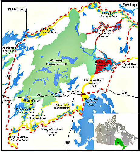
Wabakimi Provincial Park lies almost entirely in the Arctic watershed just north of the primary (or continental) Atlantic/Arctic Height of Land. Within the park, this drainage system is subdivided by the secondary Ogoki/Albany Height of Landwhich separates the watersheds of the park's two major waterways – the Ogoki and Albany Rivers.
The Ogoki River bisects the park flowing across it from west to east and most of Wabakimi lies in its drainage basin. All rivers in the southern part of the park drain north into the Ogoki River. From west to east, they are the Flindt, Allanwater, Nemo, Lookout, Boiling Sand, Caribou and Raymond Rivers. From the north, the Palisade River, Webster Creek, Corky Creek, Slim River, Grayson River and Montcrief River flow south into the Ogoki River. The Brightsand River which lies south of Wabakimi is also part of the Ogoki River drainage system. It flows north into the park and becomes the Allanwater River when it passes beneath the Canadian National Railway (CNR) line at Allanwater Bridge. |
|
The Albany River flows east to Hudson Bay from Lake St. Joseph and abuts the extreme northern boundary of Wabakimi. The Pashkokogan, Misehkow, Greenmantle, Shabuskwia, Witchwood, Attwood and Opichuan Rivers drain north into the Albany River. Due to their respective distances from the nearest road or rail access point and the current lack of reliable canoe route information, the waterways of Wabakimi that lie in the Albany River watershed constitute the least travelled and most remote part of the park.
The only waterway in Wabakimi that lies in the Atlantic watershed is the Pikitigushi River which flows south out of park into Lake Nipigon. Several protected areas also lie in this drainage system including Kopka River, Whitesand, Ottertooth-Obonga and Gull River Provincial Parks as well as Ottertooth and Lake Nipigon Conservation Reserves.
The 'drop and pool' characteristic of these waterways features extended sections of river with barely perceptible currents interspersed with close stretches of roaring, often unrunnable rapids. Occasionally, major rivers widen into very large water bodies the most significant of which are Wabakimi, Whitewater, Whiteclay, Smoothrock, Heathcote, Shabuskwia, Brennan and Smoothrock.
Across the breadth of the park, the elevation difference is less than 100 metres (330'). There are very few waterfalls with significant vertical drops. Many so-called 'falls' are actually 'chutes' where a waterway plunges through a narrow gorge created by a fault in the Canadian Shield or 'cascades' where a waterway drops through a series of smaller waterfalls. Challenging opportunites for whitewater canoeists do exist however, particularly on the Allanwater and Ogoki Rivers and in the adjacent Albany and Kopka River Provincial Parks.
Ontario's provincial parks are operated by Ontario Parks under authority of the Provincial Parks and Conservation Reserves Act and are planned, developed and managed according to the policies described in the Provincial Parks Planning and Management Policies commonly called "The Blue Book". These policies include:
The original core area of Wabakimi Provincial Park is classified as a wilderness park in order to achieve the provincial park system target for wilderness parks in each eco-region. Classification of the expansion area will be determined through the park management planning process. During development of the park management plan, the classification of the 1983 regulated area will be evaluated, the ultimate classification of the expansion area will be determined and significant decisions regarding resource stewardship, operations, and permitted development, land uses and recreation activities will be made. Ultimately, the whole of Wabakimi could become a wilderness park, a natural environment park or some combination of these two classifications.
A description of land uses and activities currently permitted in Wabakimi Provincial Park may be found in Policy Report P2558: Wabakimi of the Crown Land Use Policy Atlas.
Notices of proposals and invitations to participate in each stage the park management planning exercise will be posted on the Environmental Registry.
- goals, principles and objectives
- a park classification system with objectives for each class of park
- a park zoning system
- policies about which uses are permitted or restricted in various classes of parks and zones
- a framework for preparing directions that guide the management of individual parks
The original core area of Wabakimi Provincial Park is classified as a wilderness park in order to achieve the provincial park system target for wilderness parks in each eco-region. Classification of the expansion area will be determined through the park management planning process. During development of the park management plan, the classification of the 1983 regulated area will be evaluated, the ultimate classification of the expansion area will be determined and significant decisions regarding resource stewardship, operations, and permitted development, land uses and recreation activities will be made. Ultimately, the whole of Wabakimi could become a wilderness park, a natural environment park or some combination of these two classifications.
A description of land uses and activities currently permitted in Wabakimi Provincial Park may be found in Policy Report P2558: Wabakimi of the Crown Land Use Policy Atlas.
Notices of proposals and invitations to participate in each stage the park management planning exercise will be posted on the Environmental Registry.