
about the maps
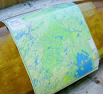
Produced by “Uncle” Phil Cotton working with a Thunder Bay cartographer, this is the only map of its kind to depict all known canoe routes in the Wabakimi Area, which includes Wabakimi Provincial Park, surrounding parks and Crown Lands in a readable scale of 1:210,000. The map is 36" tall x 35" wide (or larger upon special request) and covers over 43,000 square kilometers (16,500 square miles) of pristine wilderness.
It is ideal for planning a canoe trip, as a conversation piece to recollect memories of past adventures or as the perfect gift for the consummate wilderness paddler in search of new canoeing opportunities. Produced unfolded, each individual map is rolled in its own mailing tube ready to be mailed or gift wrapped.
Information about primary and secondary heights of land, lakes and rivers and provincial park and conservation reserve boundaries are drawn from the Ontario Ministry of Natural Resources (OMNR) data set. The backdrop of the map is a "3-D" geotiff image created from the OMNR 20m Digital Elevation Model. Printed in full color on sturdy high quality glossy paper, it provides a striking impression of the area topography.
Grid lines every 30 minutes of longitude and every 15 minutes of latitude define the coverage of the 1:50,000 Provincial Series of topographical maps over the entire extent of the map. Topo map index numbers are provided at the grid intersection points.
|
Wabakimi Canoe Route Volumes
Volumes are bound in separate volumes according to their location in a particular watershed and are designed to be taken into the field to complement the use of 1:50,000 NTS topographical maps.
Each map is produced in full colour on high quality 8.5" x 11.0" paper, and is assigned a descriptive title that indicates the extent of coverage and the direction of flow of the main intervening waterway. Canoe route values such as campsites and portages are shown. Accurately measured portage lengths are expressed in metres to make them compatible with topo maps. Locations of outpost camps and lodges are included where assistance may be obtained should an emergency arise. The maps are uniform in scale and each overlaps adjoining maps for seamless coverage of a canoe route. Enlargement circles provide magnified details of portages as well as hazards or obstacles such as swifts, rapids and waterfalls. Detailed MAP DESCRIPTIONS |
Wabakimi Canoe Routes Planning Map
|