
|
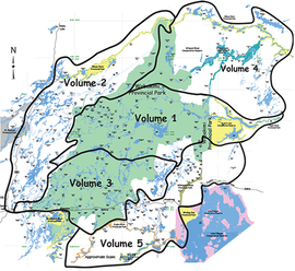
Sets of canoe route maps are bound in five separate volumes according to their location in a particular watershed as depicted here. Each volume contains a table of contents, a coverage map showing the routes included and detailed information about the Wabakimi Project and the Wabakimi Area.
Proceeds from the sale of these map booklets are used to underwrite future reconnaissance expeditions to explore, rehabilitate and document canoe routes in the Wabakimi Area and to maintain routes already established. |
Click the map to view a PDF version of this map.
|
|
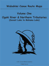
Volume One
Covers from Savant Lake east to Mahamo Lake just north of the Ogoki River downstream from the Ogoki Reservoir. The northern tributaries of the Ogoki River contained in this booklet include the Palisade River, Webster Creek, Corky Creek, Slim River, Dawn Creek and Grayson River.
|
|
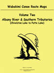
Volume Two
Covers from Chivelston Lake north through Savant Lake to Osnaburgh Lake and east along the Albany River as far as Patte Lake. The southern tributaries of the Albany River contained in this booklet include Harold Creek, Jutten Creek, Virginian Creek, Savant River, Little Savant River, Neverfreeze Creek, McCrae Creek, Redmond Creek, Shoe Creek,Wet Creek, Pashkokogan River, Little Pashkokogan River and the Misehkow River.
|
|
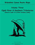
Volume Three
Covers from Harris Lake east to Little Caribou Lake and south to Maggotte Lake below the Kopka River. The southern tributaries of the Ogoki River contained in this booklet include Devizes Creek, Smye Creek, Flindt River, Allan Water River, Nemo River, Boulder Creek, Lookout River, Boiling Sand River, Caribou River and Brockway Creek.
|
|
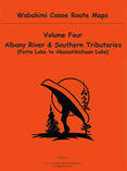
Volume Four
Covers east along the Albany River from Patte Lake to Abizotikichuan Lake and includes the route to Fort Hope on Eabamet Lake. The southern tributaries of the Albany River contained in this booklet include the Greenmantle, Shabuskwia, Witchwood, Attwood, Cat Tail and Opichuan Rivers as well as Petawa Creek all of which are historically significant waterways that link the Albany and Ogoki Rivers.
|
|
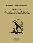
Volume Five
Covers from Redsand Lake to North Ombabika Bay on Lake Nipigon and includes all of Kopka River, Collins River, Vale Creek, Badwater Creek, Big River, Linklater Creek and the navigable portions of the Wabinosh, Pikitigushi and Little Jackfish Rivers.
|
|
Wabakimi Canoe Routes Planning Map
The new 36” x 35“ planning map incorporates the work of The Wabakimi Project and thousands of hours of volunteer efforts clearing and improving historic canoes routes and portages. The online price of the Map is $65 CAD plus shipping and handling. |
|
|
< Click to view cart
|
ABOUT ORDERING ONLINEWe are now taking online orders through PayPal. These orders may be placed using a credit card. The purchaser does not need a PayPal account to make transactions. All prices and transactions are in Canadian currency. PayPal converts all other currencies to CAD. Map volumes are $33 each for FOW members and $39 each for non-members. Shipping for map volumes is $5 per map volume. Planning maps are $65 each and there is a single $13.25 charge for shipping. Please contact us to determine shipping costs for all map orders outside of Canada and US. |
about the mapsWabakimi Canoe Route Volumes
Volumes are bound in separate volumes according to their location in a particular watershed and are designed to be taken into the field to complement the use of 1:50,000 NTS topographical maps.
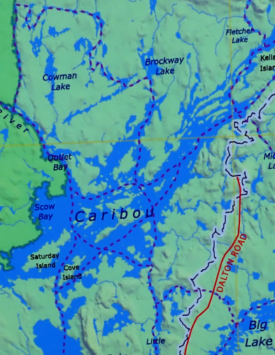
Each map is produced in full colour on high quality 8.5" x 11.0" paper, and is assigned a descriptive title that indicates the extent of coverage and the direction of flow of the main intervening waterway. Canoe route values such as campsites and portages are shown. Accurately measured portage lengths are expressed in metres to make them compatible with topo maps. Locations of outpost camps and lodges are included where assistance may be obtained should an emergency arise. The maps are uniform in scale and each overlaps adjoining maps for seamless coverage of a canoe route. Enlargement circles provide magnified details of portages as well as hazards or obstacles such as swifts, rapids and waterfalls. Detailed MAP DESCRIPTIONS |
Wabakimi Canoe Routes Planning Map
Produced by “Uncle” Phil Cotton working with a Thunder Bay cartographer, this is the only map of its kind to depict all known canoe routes in the Wabakimi Area, which includes Wabakimi Provincial Park, surrounding parks and Crown Lands in a readable scale of 1:210,000. The map is 36" tall x 35" wide (or larger upon special request) and covers over 43,000 square kilometers (16,500 square miles) of pristine wilderness.
It is ideal for planning a canoe trip, as a conversation piece to recollect memories of past adventures or as the perfect gift for the consummate wilderness paddler in search of new canoeing opportunities. Produced unfolded, each individual map is rolled in its own mailing tube ready to be mailed or gift wrapped. Information about primary and secondary heights of land, lakes and rivers and provincial park and conservation reserve boundaries are drawn from the Ontario Ministry of Natural Resources (OMNR) data set. The backdrop of the map is a "3-D" geotiff image created from the OMNR 20m Digital Elevation Model. Printed in full color on sturdy high quality glossy paper, it provides a striking impression of the area topography. Grid lines every 30 minutes of longitude and every 15 minutes of latitude define the coverage of the 1:50,000 Provincial Series of topographical maps over the entire extent of the map. Topo map index numbers are provided at the grid intersection points. 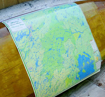
|
|
Volume One
|
Volume Two
|
|
1. Savant Lake to Tew Lake via Ogoki River
2. Tew Lake to Lower Wabakimi Lake via Ogoki River 3. Wabakimi Lake to Whitewater Lake via Ogoki River 4. Wabakimi Lake to Smoothrock Lake via Lower Wabakimi Lake 5. Smoothrock Lake to Ogoki River via Berg River 6. Smoothrock Lake to Whitewater Lake via McKinley River 7. Whitewater Lake 8. Whitewater Lake to Whiteclay Lake via Ogoki River 9. Whiteclay Lake to Ogoki Reservoir via Ogoki River 10. Ogoki Reservoir to Mojikit Channel 11. Ogoki Reservoir to Mojikit Lake via Mojikit Channel 12. Ogoki Reservoir to Mahamo Lake via Ogoki River 13. Davies Lake to Ahleen Lake via Palisade River 14. Rockcliff Lake to Palisade River via Webster Creek 15. Webster Lake to Ahleen Lake via Corky Creek 16. Ahleen Lake to Kenoji Lake via Palisade River 17. Kenoji Lake to Whitewater Lake via Grayson River 18. Dawn Lake to Arril Lake via Dawn Creek 19. Dawn Lake to Slim Lake via Slim River |
1. Chivelston Lake to Savant Lake via Harold Lake 2. Smye Lake to Savant Lake via Jutten Lake 3. Smye Lake to Savant Lake via Kneehigh Lake 4. Virginian Lake to Savant Lake via Virginian Creek 5. Savant Lake South 6. Savant Lake North 7. Savant Lake to Velos Lake via Savant River 8. Savant Lake to Velos Lake via Little Savant River 9. Jabez Lake to McCrea Lake via McCrea Creek 10. Velos Lake to East Pashkokogan Lake via Savant River 11. Little Savant River to Davies Lake via Redmond Creek 12. Takeoff Lake to McCrea Lake via Shoe Lake 13. Fitchie Lake to Savant Lake via Neverfreeze Creek 14. Fitchie Lake to Minchin Lake via Little Pashkokogan River 15. Fitchie Lake to Minchin Lake via Pashkokogan River 16. Minchin Lake to Pashkokogan Lake via Pashkokogan River 17. Pashkokogan Lake to Osnaburgh Lake via Pashkokogan River 18. Osnaburgh Lake to Atikokiwam Lake via Albany River 19. Atikokiwam Lake to Achapi Lake via Albany River 20. Achapi Lake to Patte Lake via Albany River - Part One 21. Achapi Lake to Patte Lake via Albany River - Part Two 22. Pashkokogan Lake to Rockcliff Lake via Misehkow River 23. Rockcliff Lake to Blow Lake via Misehkow River 24. Blow Lake to Albany River via Misehkow River - Part One 25. Blow Lake to Albany River via Misehkow River - Part Two 26. Early Lake to Misehkow River via Coles Lake |
|
Volume Three
1. Harris Lake to Heathcote Lake via Neston Lake
2. Heathcote Lake to Wilkie Lake via Smye Lake 3. Heathcote Lake to Flindt Lake via Flindt River 4. Flindt Lake to Tew Lake via Flindt River 5. Heathcote Lake to Allanwater Bridge via Barrington Lake 6. Allanwater Bridge to Termite Lake via Allan Water River 7. Flindt Lake to Brennan Lake via Gault Lake 8. Brennan Lake to Granite Lake via Allan Water River 9. Granite Lake to Wabakimi Lake via Allan Water River 10. Redhead Lake to Brennan Lake via Nemo River 11. Snake Lake to Brennan Lake via Jeep Lake 12. Dagger Lake to Granite Lake via Otter Bluff Lake 13. Granite Lake to Lower Wabakimi Lake via McWade Lake 14. Elf Lake to Smoothrock Lake via South Lake 15. Baldhead Lake to Onamakawash Lake via Lookout River 16. Onamakawash Lake to Smoothrock Lake via Lookout River 17. Collins Lake to Smoothrock Lake via Boiling Sand River 18. Collins Lake to Tempest Lake via Shawanabis Lake 19. Maggotte Lake to Shawanabis Lake via Boulder Lake 20. Tew Lake to Lower Wabakimi Lake via Ogoki River 21. Wabakimi Lake to Smoothrock Lake via Lower Wabakimi Lake 22. Little Caribou Lake to Caribou River via Caribou Lake 23. Caribou Lake to Smoothrock Lake via Caribou River 24. Caribou Lake (Outlet Bay) to Caribou Lake (Brockway Bay) via Brockway Lake |
Volume Four
1. Patte Lake to Miminiska Lake via Albany River
2. Miminiska Lake to Petawanga Lake via Albany River 3. Petawanga Lake to Triangular Lake via Albany River 4. Triangular Lake to Abizotikichuan Lake via Albany River 5. Shabuskwia Lake to Patte Lake via Shabuskwia River 6. Misehkow River to Shabuskwia River via Greenmantle River 7. Shabuskwia Lake 8. Shabuskwia Lake to Luella Lake Lake via Kilbarry Lake 9. Luella Lake to Attwood Lake via Attwood River 10. Attwood Lake to Peninsular Lake via Attwood River 11. Peninsular Lake to Triangular Lake (Gowie Bay) via Albany River 12. Peninsular Lake to Kellow Lake via Cat Tail River 13. Kellow Lake to Abizotikichuan Lake via Opichuan River 14. Kagianagami Lake to Kellow Lake via Opichuan River 15. Kagianagami Lake (Humble Bay) to Elbow Lake via Muskrat Lake 16. Mahamo Lake to Kagianagami Lake via Opichuan River 17. Whiteclay Lake to Grinch Lake via Witchwood River 18. Grinch Lake to Hurst Lake via Witchwood River 19. Attwood Lake to Petawanga Lake via Petawa Creek 20. Eabamet Lake to Triangular Lake via Eabamet River |
Volume Five
1. Tamarack Lake to Rushbay Lake via Canon Lake
2. Tamarack Lake to Tunnel Lake via Rocky Island Lake
3. Tunnel Lake to Waweig Lake via Vale Creek
4. Rushbay Lake to Bukemiga Lake via Collins River
5. Rushbay Lake to Mountain Portage via Vale Creek
6. Mattice Lake to Nameiben Lake via Pillar Lake
7. Waweig Lake to Lake Nipigon via Wabinosh River
8. Shawanabis Lake to Maggotte Lake via Boulder Creek
9. Caribou Lake to Upper Pawshowconk Lake via Linklater Creek
10. Caribou Lake to D’Alton Lake via Fuchsite Lake
11. D’Alton Lake to Moonshine Lake via Big River
12. Little Caribou Lake to Big Lake
13. Big Lake to Gort Lake via Big River
14. Butland Lake to Pikitigushi Lake via Pikitigushi River
15. Mojikit Lake to Zigzag Lake via Little Jack sh River
16. Zigzag Lake to Lake Nipigon via Little Jack sh River
17. Redsand Lake to Gaal Lake via Kopka River
18. Gaal Lake to Sandison Lake via Kopka River
19. Sandison Lake to Kenakskaniss Lake via Kopka River
20. Kenakskaniss Lake to Bukemiga Lake via Kopka River
21. Bukemiga Lake to Wabinosh Lake via Kopka River
22. Redsand Lake to Sparkling Lake via Kashishibog River
23. Sparkling Lake to Harmon Lake via Brightsand River
24. Harmon Lake to Antler Lake via Brightsand River
25. Antler Lake to Allanwater Bridge via Kopka River