
|
This report challenges the official government account issued by Natural Resources Canada (NRCan) each year of how forests in Canada are faring--The State of Canada’s Forests Annual Report. Drawing upon scientific evidence, data, and metrics, this report deconstructs the government’s overly positive portrayal of the Canadian forestry sector.
It introduces the basic factors Canada omits from these annual reports to arrive at its self-congratulatory conclusions, presenting evidence that the actual state of the forests is far more complex and worrisome, and the logging industry far less sustainable, than the government claims. Read the Report here! Policy Recommendations Transparent. Comprehensive. Balanced.
0 Comments
From THE NARWHAL:
New mineral claims within Grass River Provincial Park raise questions about the impacts of the race to mine ‘the building blocks for the green and digital economy’ on threatened species. Manitoba’s efforts to champion its critical mineral sector may be putting one of the province’s most iconic species at risk. During the Prospectors and Developers Association of Canada conference in Toronto earlier this month, Manitoba doubled down on its critical mineral commitments as it revealed the latest round of funding distributed under the Manitoba Mineral Development Fund. Critical minerals have been dubbed by the federal government to be the “the building blocks for the green and digital economy.” Among the $3.3 million in mineral development funds announced was a $300,000 grant to nickel mining company NiCan Limited to support “ongoing drill exploration” inside Grass River Provincial Park in northern Manitoba — a park the government describes as “a place where woodland caribou thrive, and where wolves, moose, bear and wolverine roam the lush forests.” But according to environmental group The Wilderness Committee, NiCan’s mineral claims don’t just fall within park boundaries — they also overlap the calving, rutting and summering grounds for a herd of threatened boreal woodland caribou. FULL ARTICLE HERE! Cutting the heck' out of Canada's boreal forest has put caribou at risk (latest from CBC news)1/21/2024 FULL STORY HERE
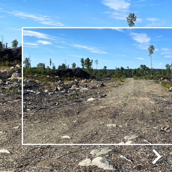
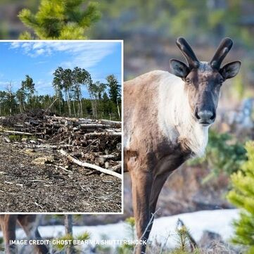
Canada is home to the largest boreal forest in the world, a vast expanse of wilderness rich in biodiversity that stretches from coast to coast. But a major new study examining nearly a half century of logging in Ontario and Quebec warns that clear-cutting has left forests in the provinces severely depleted — and puts woodland caribou at risk. The peer-reviewed research, published in the academic journal Land, found that logging practices between 1976 and 2020 have resulted in the loss of more than 14 million hectares of forest, an area roughly twice the size of New Brunswick. There are only 21 million hectares of older forest (defined as forests 100 years or older) remaining in the region. "We have been cutting the heck out of the boreal forest," said Jay Malcolm, a professor emeritus of forestry at the University of Toronto, and one of the authors of the study, conducted by researchers in Canada and Australia. The researchers calculated that older forests make up only 42 per cent of the forest area, and most of the remaining older forest is in the remote north. "It's very frightening. It was startling to see how little is left and how badly fragmented it is," said Malcolm. Read the rest here.
New study suggests federal government underreports greenhouse gases from forestry sector. (CBC News · Posted: Jan 16, 2024 (Full story here.)
Canada's forestry sector is responsible for far more greenhouse gas emissions than show up in official tallies, potentially leading to policies that aren't in line with the country's climate goals, a new study suggests. The peer-reviewed study, published in the academic journal Frontiers in Forests and Global Change, found that annual greenhouse gas emissions attributable to forestry between 2005 and 2021 were, on average, nearly 91 million tonnes of carbon dioxide equivalent — which would put the sector on par with emissions from the agricultural sector. (This was a joint study by scientists David Bysouth, Julee Boan, Jay R. Malcolm and Anthony R. Taylor.) By contrast, Canada's official inventory report shows the forestry sector acting as a carbon sink, which means it absorbs more carbon from the air than it sends into the atmosphere. The report has the sector absorbing an average of five million tonnes of carbon dioxide equivalent annually over the same period. Halifax Examiner Today: "Canadian Governments Fail to Count Environmental Costs of Industrial Logging" ----New report from eight leading North American and Canadian environmental organizations. A new report, The State of the Forest in Canada: Seeing Through The Spin, from eight leading North American environmental groups shows that the federal government is failing to tally the environmental and climate damage caused by industrial logging in Canada. ....the report “shows that Natural Resources Canada (NRCan)’s annual report downplays or ignores the significant impacts of industrial logging on biodiversity, the climate, forest integrity, and ecosystem services, and its potential infringements of Indigenous rights.” The report accuses Natural Resources Canada of failing “to provide Canadians with a transparent and credible synopsis” of basic information about the state of the nation’s forests, and of using “highly selective statistics and distorting or excluding essential information.” New study finds more than 14 million hectares cut in Ontario and Quebec since 1976New study finds more than 14 million hectares cut in Ontario and Quebec since 1976
Link to full story here! Canada is home to the largest boreal forest in the world, a vast expanse of wilderness rich in biodiversity that stretches from coast to coast. But a major new study examining nearly a half century of logging in Ontario and Quebec warns that clear-cutting has left forests in the provinces severely depleted — and puts woodland caribou at risk. The peer-reviewed research, published in the academic journal Land, found that logging practices between 1976 and 2020 have resulted in the loss of more than 14 million hectares of forest, an area roughly twice the size of New Brunswick. There are only 21 million hectares of older forest (defined as forests 100 years or older) remaining in the region. Link to full story here! A study finds that logging has inflicted severe damage to the vast boreal forests in Ontario and Quebec, two of the countryʼs main commercial logging regions. By Ian Austen and Vjosa Isai Ian Austen reported from Ottawa, and Vjosa Isai from Toronto. Canada has long promoted itself globally as a model for protecting one of the country’s most vital natural resources: the world’s largest swath of boreal forest, which is crucial to fighting climate change. But a new study using nearly half a century of data from the provinces of Ontario and Quebec — two of the country’s main commercial logging regions — reveals that harvesting trees has inflicted severe damage on the boreal forest that will be difficult to reverse. Researchers led by a group from Griffith University in Australia found that since 1976 logging in the two provinces has caused the removal of 35.4 million acres of boreal forest, an area roughly the size of New York State. While nearly 56 million acres of well-established trees at least a century old remain in the region, logging has shattered this forest, leaving behind a patchwork of isolated stands of trees that has created a landscape less able to support wildlife, according to the study. And it has made the land more susceptible to wildfire, scientists say. Read the full article here! "As part of the study, Professor Mackey and other researchers looked at the effects of logging on large groups of woodland caribou — animals that require large areas of older forest and that are affected by human disturbance. Logging roads, for example, make it easier for predators to hunt caribou, researchers said. Of the 21 herds within the two provinces’ boreal regions that researchers studied, 19 were at a high or very high risk of becoming unable to support their population." Leading ENGOs call on Canada to address forest degradation & Defining Forest Degradation in Canada12/14/2023 Biodiversity and climate crises deeply entwined (SEE ENTIRE ARTICLE HERE)
[Also Defining Forest Degradation in Canada - Article Here) Reposted from the David Suzuki Foundation: Canada cannot deliver on its global commitments to halt and reverse land degradation by 2030 unless it first accurately defines forest degradation, a coalition of leading environmental organizations working in Canada says. Today seven organizations released a science-based definition to spur urgently needed action. Canada’s commitment to halt and reverse the degradation of forest ecosystems by 2030 is an important part of the global effort to address the biodiversity and climate crises. However, while forest degradation is a scientifically grounded and internationally recognized issue, Canada has yet to articulate a credible framework to identify and eliminate the degradation that continues to occur not only in what remains of primary, old-growth and other high-integrity forests, but also within the wider managed forest. At present, Canada tracks rates of deforestation — the conversion of natural forests to another use — but does not track domestic forest degradation, of which industrial logging practices are a leading cause. As scientists have articulated, when a forest is degraded, its ability to provide critical ecosystem services such as climate mitigation, wildlife habitat and water filtration, diminishes. There is clear evidence that industrial logging degrades forests in Canada. For example, boreal woodland caribou, which require large expanses of mature and interconnected intact forests to survive, are currently threatened with extinction across the country due, primarily, to a legacy of disturbance from industrial activities including logging. Logging has so significantly degraded old-growth forests in British Columbia that the spotted owls that used to live there are now considered functionally extinct. See rest of the article here!
Originally published in the newsletter of the Thunder Bay Field Naturalists: Nature Northwest February 2023, Vol 77(1):15-19. Its about time the under-appreciated black spruce (Picea mariana) receives the attention and recognition it deserves. It’s resilience, economic importance and pan-Canadian distribution make it the stalwart, humble and inspirational icon of the Canadian boreal forest. Let’s celebrate its’ many contributions to Canadian life and psyche. Forget the geographically limited sugar maple and picturesque wind-swept white pine and let us respect black spruce as the most important and consequential Canadian forest tree. The black spruce is resilient and has robust, diverse and effective survival strategies. It reflects the legendary Canadian resilience demonstrated by indigenous peoples and early immigrants to cope with harsh and varied environmental conditions and a raw and rugged physical landscape. See Full Article here too, with more photos. (Thanks to Gerry for permission to reprint this article.) " ...the black spruce is an iconic Canadian tree species and deserves to be recognized as such. It should be our National Tree." https://www.tbnewswatch.com/local-news/meeting-shows-challenges-on-caribou-protections-7716660?utm_source=TBNewsWatch&utm_campaign=44daf291c3-LocalTB&utm_medium=email&utm_term=0_adfb678056-44daf291c3-45691759
(Ian Kaufman-reporting) THUNDER BAY — A provincial workshop held in Thunder Bay this week illuminated a challenging road ahead in reaching agreement on adequate protections for the threatened boreal caribou. The issue has wide implications not just for the future of the caribou, but for forestry, mining, and hunting in Northern Ontario. Federal Environment Minister Steven Guilbeault warned earlier this year Ontario is not effectively protecting some boreal caribou habitat, pointing to exemptions under Ontario's Endangered Species Act allowing mining exploration, for example. Guilbeault said he was required under the Species At Risk Act to recommend a habitat protection order, but the feds gave Ontario until April 2024 to present a plan showing that's not needed. Just how far a protection order would go in limiting activities like resource extraction isn’t clear, but Ontario politicians and industry players responded with alarm, saying it could devastate mining and forestry in the North. That issue loomed over a workshop organized in Thunder Bay this week by Ontario’s Ministry of Natural Resources and Forestry to discuss a way forward. Dougall Media reporters were not allowed to observe the workshop, but spoke with several participants, who described it as a productive, but sometimes tense, conversation between researchers, environmental advocates, political leaders, and industry players with competing values and priorities. Marathon Mayor Rick Dumas, representing the Northwestern Ontario Municipal Association (NOMA) at the meeting, said northerners are sensitive to environmental pronouncements from outsiders. “When you [have] people from the south telling people in the north how we're going to protect your lands, we get our backs up,” he said. “We're the real environmentalists — we’re the real protectors of the land, because we live here. We want to make sure our landscape and our future for our children and grandchildren are sustainable, but we want to do it in a practical, common-sense way.” The woodland caribou are listed as threatened both provincially and federally. Researchers estimate there are roughly 5,000 left in Ontario. The population was once widespread north of Lakes Huron and Superior, but human settlement largely shrunk its range to areas north of Sioux Lookout, Geraldton, and Cochrane, along with some isolated populations along the Lake Superior shoreline and islands. The province and feds agreed to collaborate on protecting woodland caribou last year. he agreement generated pushback, with environmental groups charging it ran counter to the Species at Risk Act by prioritizing economic considerations. Northern Ontario municipalities, by contrast, called the agreement too aggressive, saying it could stifle mining and forestry they depend on. “We all want to protect the species at risk… but the reality is we also have to protect the species at risk which is us, the humans that live on the landscape,” said Dumas. Because caribou have virtually disappeared in areas along Lake Superior in the “discontinuous zone,” Dumas argues the province should focus conservation efforts further north, where they’ll also impact industry less. “We live in the backyard, and I’ve said through this session, there is no caribou on the mainland in the discontinuous zone,” he said. “If there’s no caribou, why are we having impacts? Why don't we focus on areas where the caribou will thrive?” John Kaplanis, executive director of the Northwestern Ontario Sportsman's Alliance, agrees. "If we're going to buy into the climate change theory, it dictates the caribou range is going to get pushed north," he said. "If that happens — and it is happening, apparently — then much of what we're doing in the southern range is all for nothing." "There's not much in the short term we think is worthwhile to do, especially if it impacts our communities so dramatically." John Fryxell, a biology professor who leads the Fryxell Lab at the University of Guelph, expressed some understanding for that argument. “My personal feeling is recognizing that some sites are going to be very difficult to recover might be a reasonable assertion, if it's balanced with increased efforts in other locations where we're perhaps not dug into such a deep hole,” he said. Rob Rempel, a retired Ministry of Natural Resources wildlife ecologist who now heads FERIT Environmental Consulting Services, agreed restoring caribou populations further south is a tall order. “There's a lot of logging and other activity going on there, [and] to re-establish care would require a large, large intervention,” he said. “In other areas… the interventions might be a lot less to have a very positive impact on caribou.” “That's really not a science question, in a way,” he added. “It's a decision society and its decision-makers must make: where do we put our effort?” Kaplanis said hunters also worry about how conservation efforts will impact species like moose, wolves, and black bears, who he said have been made “scapegoats” for caribou decline. “The big concern has been how it relates to moose management,” he said. “Our position is moose in the continuous caribou range are already at very low densities.” Researchers say evidence has clearly established competition with moose and wolves is a major factor in caribou decline, but add that’s largely driven by resource extraction — and now exacerbated by climate change. The combination of a warming north and forestry that replaces older growth forests, friendly to caribou, with new growth more amenable to moose, is increasing moose populations and shifting them north, Rempel said. That in turn fuels an increase in the wolf population, which has increased predation on caribou. He added features like logging roads, while small on the landscape, can have a big impact. Wolves use the pathways to travel large distances more quickly while hunting, giving them an advantage. Fryxell called strategies like closing off old logging roads one solution, though even that comes with trade-offs. “Those access routes are something people love — it lets us have recreational opportunities, but at the same time it makes it much easier for wolves to have a very high impact,” he said. Rempel acknowledged tension between conservation and economic interests. “I think that definitely complicates efforts,” he said. “The best science-based approach might be that we should stop all logging… but that’s not a reality, because people are important too, communities and economies are important.” Daniel Fortin, a Laval University biology professor, said the workshop aimed to identify strategies that balance the two. Some potential actions include habitat restoration, eliminating vegetation preferred by moose to reduce the moose and wolf populations, and leaving larger patches of forest untouched during logging. Fortin pointed to a federal Recovery Strategy for the Woodland Caribou that suggests leaving a minimum of 65 per cent of caribou habitat undisturbed. NOMA has argued following the standard could devastate the region’s economy. Fortin said the correlation has been strongly established by research, however. “If you log over 35 per cent, on average, you could expect your population has probably a 40 per cent chance to decrease,” he said. “If you log at 40 per cent, it's probably a 50 per cent chance.” While deep divisions remain on some issues, workshop participants expressed optimism. “I hope this meeting we've had, as painful as it can be to confront these facts, is the first [step] to try to come to grips with that,” said Fryxell. “We have a lot of sharp dialogue for sure, but at the end of the day, I think we all have a common vision of the kind of northern landscape we'd like to leave for our grandchildren and great-grandchildren.” |
AuthorJoin the Conversation and be part of Process Archives
May 2024
Categories |
©2020 Friends of Wabakimi All Rights Reserved