
|
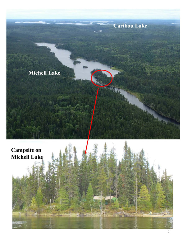
The Friends of Wabakimi (FOW) has proposed four new Conservation Reserves and limitations on planned logging roads with our formal comments for the Wabadowgang Noopming (W.N.) Forest ten year plan (2023 to 2033). These four areas are closely proximate to Wabakimi Provincial Park and within the woodland caribou special area of concern. The FOW also clarified that Trail Lake (aka Tamarack Lake) Road should remain undeveloped so as to not cause increased pressure onsensitive caribou areas in Wabakimi Provincial Park’s SE corner. The FOW represents wilderness paddlers and recreational businesses with a current membership of over 250 who have an interest in the Greater Wabakimi Area. The FOW is the successor organization to The Wabakimi Project, which explored and mapped routes, portages and campsites over a fourteen year period. The maps for the W.N. Forest are contained in Wabakimi Canoe Routes Volume 5. FOW President Vern Fish is our representative on the W.P. Forest Local Citizens Committee (LCC). Previously, FOW met with the MNRF and their consultants. Of significance is Ontario’s Crown Land Use Policy Atlas Policy (CLUPA) Report G2616: Caribou Lake / Wabakimi, adopted in 2006, which states, “The primary use for this area will be commercial tourism. Extractive activities such as timber harvesting, while growing in importance, will remain secondary. Road access will be managed to maintain commercial tourism and fish and wildlife habitat. Land use conflicts will be resolved recognizing the importance of commercial recreation in the area.” Proposed Conservation Reserves While creation of new Conservation Reserves is outside the purview of the Ministry of Natural Resources Forestry’s (MNRF) forest planning process; it is within the broad responsibilities of the MNRF generally.
The D’Alton Block has an unusual high concentration of interconnected small lakes and rivers. It has been documented as historical caribou habitat and migration corridors. There are several valuable remote tourism outposts scattered across the “block”. This tangle of lakes has the potential to be enhanced for recreational canoeing and creates opportunities for canoe outfitting for the Whitesands community. Currently, canoeing access to the D’Alton Block is limited to portaging in from Caribou Lake. If the existing Big Lake Road were opened to recreational use up to the stream crossing just south of Big Lake, another route would be available to paddlers. This limited access would still maintain the wilderness character of the outpost cabins. It would also help reduce canoeing pressure on caribou calving on Caribou Lake in May and June. 4. Doe-Fawn Lake Complex – This area is located north and northeast of Collins. It is bounded on the south by the CNR Line, on the west and north by Wabakimi Park and on the east by Fawn and Doe Lakes. This area features shallow soils and is important currently used year-round caribou habitat. This small but important area deserves status as a Conservation Reserve to protect this caribou habitat. Eliminating or limiting road access and designating the area west of Doe and Fawn Lakes as a Conservation Reserve will accomplish both of these goals. Roads inside of CLUPA G2616. We are recommending some areas within CLUPA G2616 for Conservation Reserve status. That designation lies outside of the scope of the forest management planning process (FMP). However, it does lie within the responsibilities of Ontario’s Ministry of Natural Resources and Forestry (MNRF), and this is a Crown FMU. The Crown Forest Sustainability Act (CFSA) makes it clear that the Minister shall not sign any FMP that is not sustainable for all forest values. So, this draft FMP can, and should:
Of particular importance for lowest possible grade, temporary (perhaps winter) roads are:
These roads should be winter roads… or left just in the current state to keep open the possibility of increased formal protection of the caribou habitat and remote recreational experience. A Sense of Wilderness According to Vern Fish, FOW President, “Our goal is to maintain a sense of wilderness in key parts of this forest… Wabakimi has important values to be preserved. Our FOW priorities and concerns are: -- Ecological integrity and sustainability -- Maintaining a healthy and sustainable woodland caribou population -- Protect lakes that support Lake Trout -- Protect exceptional recreation and tourism values adjacent to Wabakimi Park: *Maintain existing and potential wilderness tourism business opportunities *Preserve historical canoe routes that directly or indirectly connect to adjacent provincial parks.” “We do understand the need for economic benefit to Whitesand First Nation, and Armstrong. We believe that the - above recommendations are consistent with long term sustainability for both the natural environment and local economy.” Contact: Vern Fish, FOW President at [email protected]
0 Comments
|
©2020 Friends of Wabakimi All Rights Reserved